Mapping the way our agricultural landscapes are used and the habitats associated with them is hugely important. Only with detailed data on the composition and structure of our agricultural landscapes can we fully understand how land management works in context and how changes might affect biodiversity and the environment. Every year since 2015, UKCEH has used high resolution satellite data to map the crops grown in all 2M fields across Great Britain. AgZero+ aims to grow and improve our remote-sensing data on agricultural landscapes.
Image

The Land Cover® Plus Crops map
The first detailed, interactive, digital maps of cropping in Great Britain, providing annual information on crop types for every field in Great Britain since 2015. UKCEH Land Cover® Plus: Crops has many applications including the production of farming statistic, environmental modelling and risk assessment.
Image
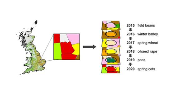
Crop rotations
We have developed methods to analyse the full set of crop maps over time to describe patterns of crop rotation across GB. Crop rotation govern the extent and timing of many agricultural management actions including tillage and agrochemical application, so diversifying rotations or modifying them with new practices such as cover crops are important routes towards more environmentally sustainable arable systems
Image
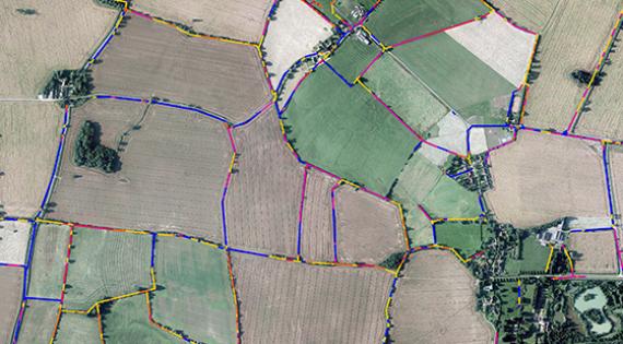
UKCEH Land Cover® Plus: Hedgerows
Hedgerows provide vital corridors of habitat for farmland wildlife and help to store carbon above and below ground. We have created the first map of England’s agricultural hedgerows with data on height, using Environment Agency LiDAR data. The boundaries of all fields in UKCEH Land Cover® Plus: Crops are mapped and assigned information on hedgerow presence and height.
Image
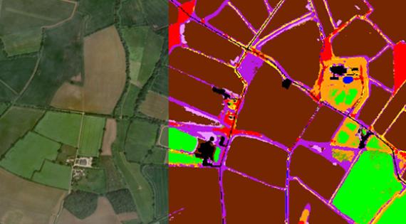
High-resolution farmland habitat mapping
Many important features of the agricultural landscape are hard to identify using traditional satellite mapping methods, as they occur in narrow strips or small patches (e.g. field margins, ditches, ponds). We are currently developing methods to classify these features from high resolution data (3-metre pixels) and so gain a more complete picture of our agricultural landscapes